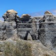
At first glance, a certain corner of Lanzarote could easily be mistaken for one of the landscapes photographed by NASA's Perseverance rover on Mars. Just off the roadside, with no signposts or entrance arch, emerges a labyrinth of columns, cornices and passageways in ochre and reddish tones, resembling an abandoned city on another planet. This is the former Teseguite quarry, a place nicknamed the "Stratified City" because of the geometry of its walls and the sequence of layers running through them. The site is striking not only for its appearance but also for what it reveals about the island: how its soil was formed, how crops are grown on volcanic ash and why erosion can create natural sculptures without the help of human intervention. The visit is short, highly photogenic, and extremely fragile, so explore it respectfully and leave no trace.
Where is Lanzarote's "Martian city"?
The site lies alongside the LZ-404, the road connecting the historic town of Teguise with the village of Guatiza. The route winds through volcanic landscapes that resemble the lunar surface and, suddenly, an amphitheatre of sculpted walls appears beside the road, breaking the monotony of the plain. On the horizon, the cone-shaped silhouettes of Tinamala and Guenia frame the scene against an unmistakably volcanic backdrop.
The rock formation appears without warning, as though it had emerged overnight, revealing its superimposed layers and hollows carved by time. The contrast between the lighter tones of some strata and the ash-grey ground intensifies the otherworldly effect, even on cloudy days.
Access and a short stop
Along the LZ-404, visitors can stop safely at a small lay-by and take a few minutes to admire the site. Pay close attention to traffic when pulling over and make sure the vehicle is parked securely before getting out.
The simplest route can be explored on foot in a short time, following the formations that are most visible from the roadside. The key is to stay off the carriageway, walk carefully and remain mindful of the fragility of the formations. Visitors should avoid entering unstable cavities or approaching cornices and arches too closely, as these features are the result of slow natural processes and are therefore particularly delicate.
Why it looks like Mars: how this landscape was shaped
The walls of the former volcanic quarry reveal, like an open book, layers of volcanic material deposited over successive eruptions. Each eruption left behind ash of different densities and grain sizes, creating a sequence of strata that are easy to identify for anyone who takes the time to look closely.
For decades, people extracted the material known locally as rofe from the site, leaving behind vertical cuts and straight lines with an almost industrial appearance. Later, wind carrying sand acted like a giant abrasive tool, while occasional but intense rainfall wore away the softer layers, rounding edges and hollowing out cavities.
The result is a mosaic of towers, passageways, arches and natural "windows" opening onto the sky, with rough textures and a palette of ochres, reds and pale tones that reinforce the sensation of standing in an alien landscape.
An open-air photography studio
The combination of shapes and layers makes this formation an ideal setting for landscape and detail photography. Shadows create sharp lines when the sun is low, while backlighting emphasises the hollows carved by erosion.
It's best to move slowly, select viewpoints from stable ground and avoid climbing on the formations to prevent damaging them or compromising their stability. On windy days, dust suspended in the air creates an atmospheric haze that enhances the landscape's mineral character. Even moving a few metres can dramatically alter the perspective and colours without requiring a long walk.
What is rofe and why did it transform agriculture in Lanzarote?
In Lanzarote, the term rofe refers to lapilli, a coarse-grained, porous volcanic ash also known as picón. Its importance became evident after the Timanfaya eruptions of 1730 to 1736, when large areas of fertile land were buried beneath volcanic material.
Once the surface layer of ash was removed, farmers discovered that moisture was retained in the soil beneath, protected by the rofe. This material captures dew during the night, channels it into the ground and reduces evaporation during the heat of the day, creating a microclimate ideal for cultivation in arid conditions.
This explains landscapes such as La Geria, where black volcanic soil stretches for kilometres, and Malvasía vines are planted in hollows protected by semicircular stone walls known as zocos.
From the quarry to the fields
The extraction of rofe from quarries such as Teseguite supported the preparation of agricultural land for many years, helping to turn volcanic ash into an agricultural asset.
Over time, natural erosion acted on the cuts left by human activity, creating the landscape visible today, so distinctive that it has become one of the island's visual hallmarks. As a result, the site can be interpreted in two ways: as an open-air classroom explaining how Lanzarote's soils were formed, and as evidence of how human activity and natural forces can combine to create landscapes of remarkable beauty.
Understanding the role of rofe also helps visitors interpret other parts of the island, from its vineyards to its terraced fields, where volcanic ash is not an obstacle but a resource.
Responsible visiting: how to enjoy the site without damaging it
The Stratified City is as fragile as it is photogenic. Many of its most striking walls and cornices are maintained by delicate balances shaped over decades by wind and rain. One misplaced step or careless jump can accelerate an irreversible collapse.
A few simple guidelines can help preserve the site:
- Do not climb on the formations or walk on ledges, arches or natural "windows".
- Stay on established paths and choose stable terrain.
- Avoid graffiti, markings or inscriptions on the rock.
- Minimise direct contact with eroded walls and edges.
An extra stop on the route: Barranco de las Piletas
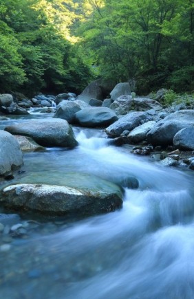
Visitors with more time can extend their trip with a walk to the nearby Barranco de las Piletas. This canyon, carved by water over thousands of years, provides a fascinating contrast to the volcanic landscape and helps explain how wind and water work together in volcanic environments.
The route offers different perspectives and textures within a relatively small area. Combining both locations enriches the experience and reinforces a key idea: Lanzarote is a landscape that can be read layer by layer, with each geological episode written over the previous one.
A nod to Mars
The stony plains, drifting dust and reddish hues associated with Mars are naturally recreated here. The comparison with Perseverance's images is therefore no coincidence: the "Martian" appearance arises from the same language of sediments, wind and rock that shapes landscapes on Earth.
The average distance between Earth and the Red Planet is around 225 million kilometres, yet beside the LZ-404 the visual resemblance feels surprisingly close. That is why this corner of Lanzarote is so startling at first glance and so captivating after a few minutes. As with any fragile landscape, the secret is simple: admire it closely, but leave it untouched.