

The Caminito del Rey is one of Spain’s most epic hiking routes, a cliffside walkway threading through the Gaitanes Gorge with huge views over the Guadalhorce River. It’s an easy day trip if you live in or are visiting southern Spain, and it’s quietly changing life in the surrounding Guadalteba region.
- What is the Caminito del Rey in Málaga?
- History of the Caminito del Rey
- How long is the Caminito del Rey?
- How difficult is the Caminito del Rey?
- Caminito del Rey route: what to expect
- Caminito del Rey tickets, prices and opening times
- Practical tips for visiting the Caminito del Rey
- How to get to the Caminito del Rey
- Living in Guadalteba
What is the Caminito del Rey in Málaga?
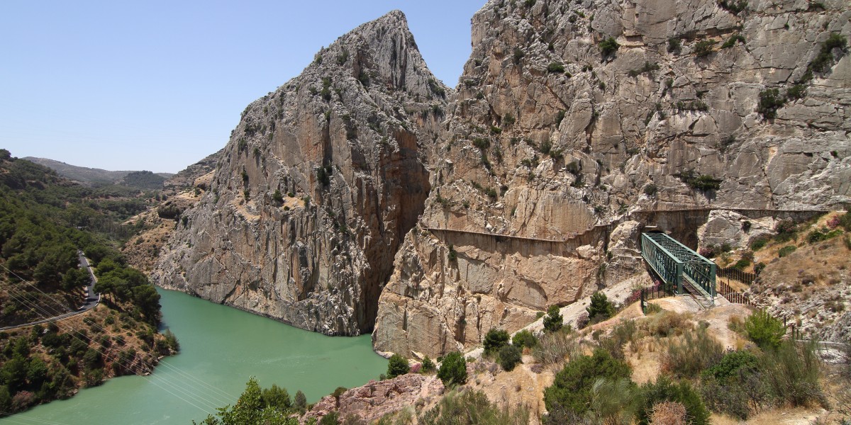
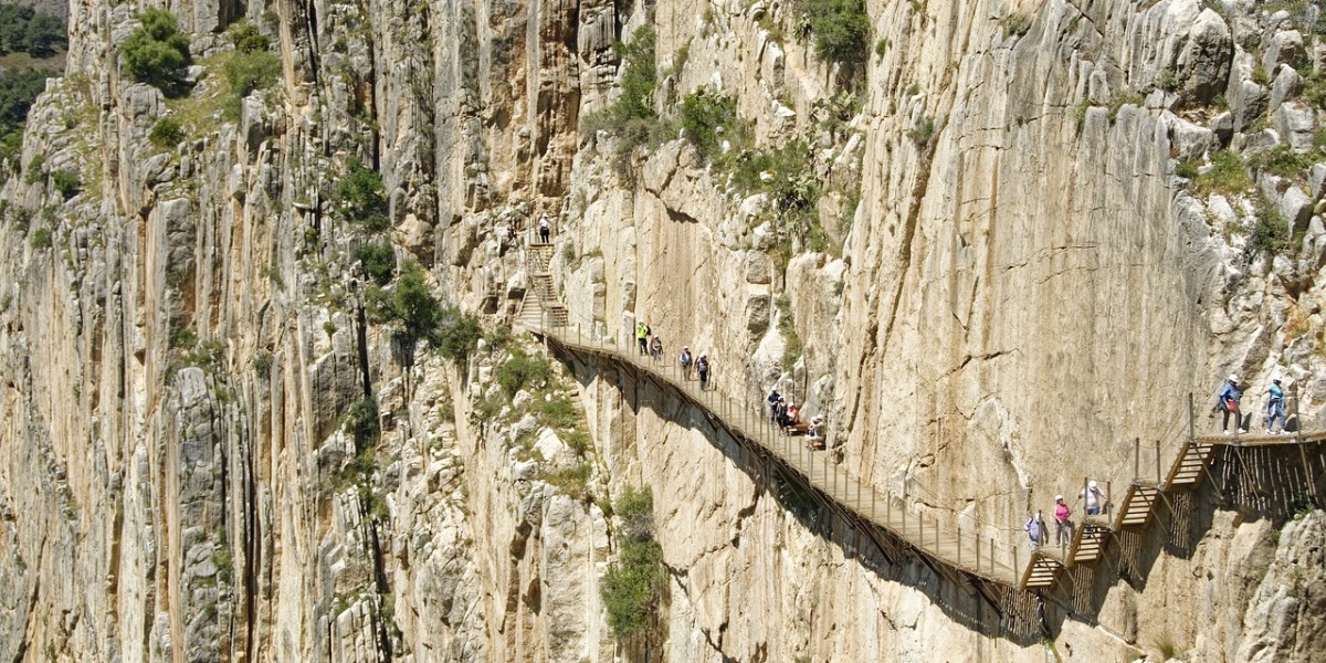
The Caminito del Rey is a linear hiking route in inland Málaga, following narrow walkways bolted to the cliffs of the Gaitanes and El Chorro gorges. It was once nicknamed one of the world’s most dangerous paths, floating over 100 metres above the Guadalhorce River.
These days it’s one of the classic outdoor days out near Málaga city and the Costa del Sol, drawing walkers from across Spain and plenty of international visitors too.
History of the Caminito del Rey
The story of the Caminito del Rey is almost as dramatic as the gorge it crosses. Built between 1901 and 1905, it started as a simple service path for workers maintaining canals and hydroelectric plants.
Its royal name dates back to 1921, when King Alfonso XIII crossed it to inaugurate the Conde del Guadalhorce dam, giving this practical walkway a bit of glamour. As the decades passed, the concrete path crumbled. Locals and climbers kept edging along it anyway, and it gained a grim reputation for accidents and for being one of the riskiest hikes around.
In 2015, the whole route was finally restored and reopened to the public. The new version uses wooden boardwalks, steel supports and solid safety railings, while the remains of the old path are still visible below.
How long is the Caminito del Rey?
The Caminito del Rey route is about 7.7 kilometres, and most people take around 3–4 hours at a steady, photo‑friendly pace. Along the way you’ll cover:
- An approach path (forest track and/or tunnel) to reach the official start
- The hanging boardwalks through the Gaitanejo and Gaitanes gorges
- A final stretch leading down towards El Chorro and the exit area
How difficult is the Caminito del Rey?
The Caminito del Rey is usually classed as an easy‑to‑moderate walk for anyone with basic fitness, but the height and exposed sections can feel intense if you are not keen on heights.
Underfoot, it is mostly flat or gently downhill, with solid wooden walkways. The challenge is more about the sheer drops, open railings, a few narrower sections and the suspension bridge-
Caminito del Rey route: what to expect
Along the Caminito del Rey you cross two dramatic gorges, Gaitanes and El Chorro, following the Guadalhorce River as it squeezes through the rock.
You can expect:
- A mix of tunnels, forest paths and narrow wooden boardwalks
- Old railway lines and hydroelectric structures from the early 1900s
- Rock formations that show off millions of years of geological history
- Birds of prey overhead and hardy plants gripping onto the cliffs
Caminito del Rey tickets, prices and opening times

Caminito del Rey ticket prices
Standard Caminito del Rey tickets are currently €10 per person for general entry, with guided tours at €18. On weekends, bank holidays and in peak season, tickets often vanish weeks ahead, so anyone fixed to particular dates is better off planning early.
Opening times and days the Caminito del Rey is closed
The Caminito del Rey usually opens at 9 am, with closing times that change by season. It is normally closed on Mondays and occasionally on specific public holidays or for maintenance.
Where to buy Caminito del Rey tickets
Caminito del Rey tickets are sold on the official website, along with a few approved partners and tour companies. Buying direct from the official site is the simplest way to be sure you have up‑to‑date information on times, closures and rules.
Practical tips for visiting the Caminito del Rey
The Caminito del Rey is well organised, but a bit of prep makes the day feel much smoother.
- Minimum age is 8 years old; younger children cannot access the route
- Helmets are mandatory and are provided at the entrance
- There are no toilets on the walkway itself, only at the entrance and exit areas
- No dogs or pets are allowed on the route
- Arrive at the access tunnel at least 30–40 minutes before your entry time, as the approach walk takes a while
The best time to walk the Caminito del Rey is generally during the cooler months of spring and autumn, or early in the morning in summer, to avoid the strongest heat and make the experience more pleasant.
How to get to the Caminito del Rey
Caminito del Rey is inland but easy enough to reach from Málaga city for a day trip.
- By car: Around 1–1.25 hours via the A‑357 towards Ardales, with parking near the north access and at El Chorro.
- By train: Direct services run from Málaga María Zambrano to El Chorro – Caminito del Rey.
- By bus and shuttle: Regional buses serve Ardales, Álora and El Chorro on limited timetables, and an official shuttle links the north and south entrances.
- Organised tours: Agencies in Málaga and the Costa del Sol offer packages including transport, tickets and sometimes a guided walk.
Living in Guadalteba
Living in the Guadalteba region in northern Málaga means trading city traffic for mountain views, reservoirs and a much slower pace of life. Villages like Ardales, Campillos and Teba sit among rolling hills, olive groves and lakes, with the Caminito del Rey and El Chorro almost on your doorstep.
Day to day, it is very small‑town southern Spain living: morning coffees in the plaza, weekly markets, and long lunches built around olive oil and cured meats. There is a strong sense of community, plenty of traditional fiestas and a mix of locals, Spanish second‑home owners and a growing number of foreign residents.
Ardales is the closest municipality to the Caminito del Rey and a handy base if you want the hiking route and the lakes to be part of everyday life rather than just a day trip.

Stay inspired for your travels in Spain—get our weekly newsletter for the latest travel guides, cultural news, and lifestyle tips.
