
Spain is home to some of the most impressive places in the world, offering tourists and residents a unique and diverse experience. National Geographic has compiled a list of Spain's seven natural wonders.
This article will explore these locations, highlighting their history and uniqueness. We'll also look at how much it costs to live in these dream locations, giving you the full picture of what it's like to live there.
Ordesa y Monte Perdido National Park
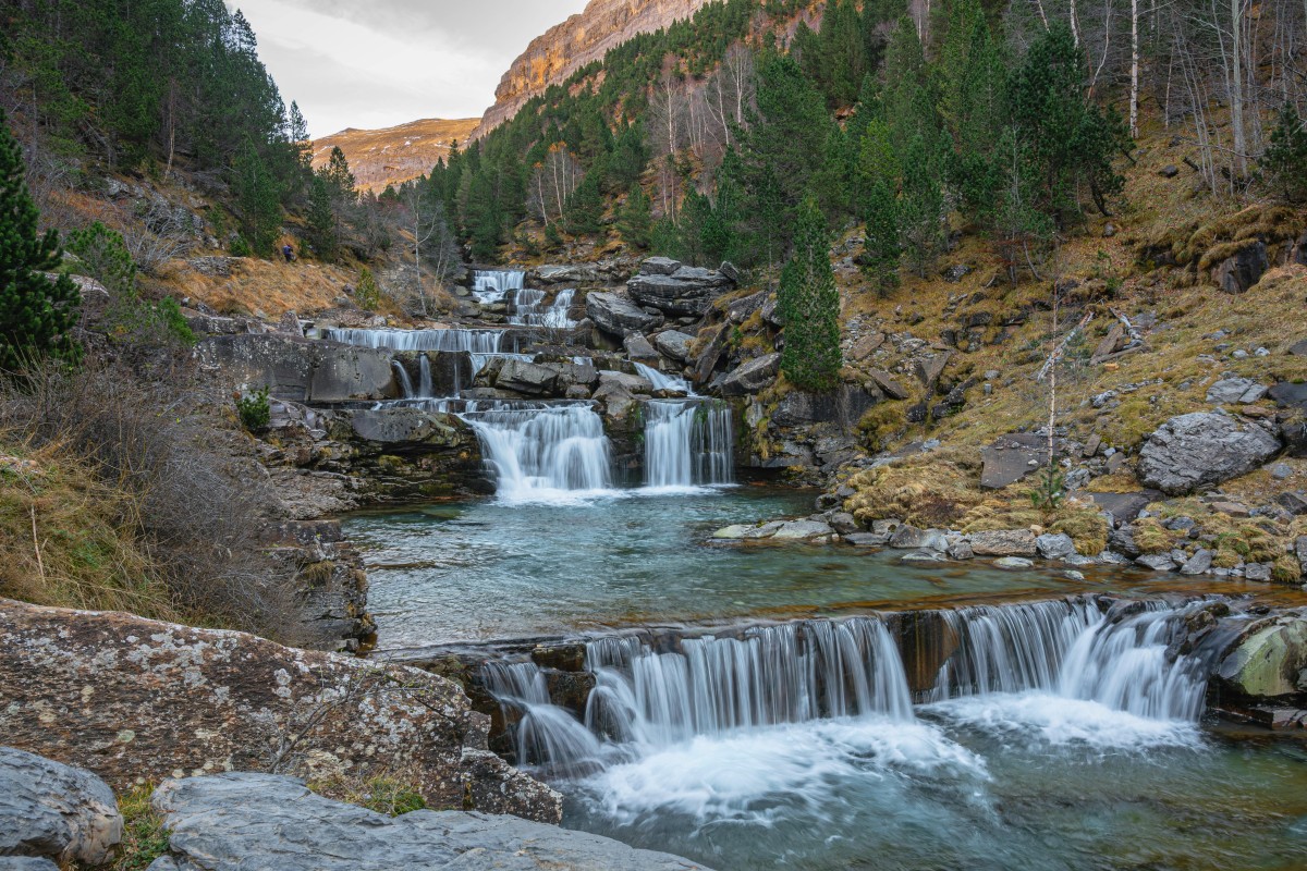
Ordesa y Monte Perdido National Park is one of Spain's most stunning natural treasures. Nestled on the southern slopes of the central Pyrenees in Huesca province, it was registered as a national park in 1918, making it the second oldest in the country.
At the heart of the park is the imposing limestone massif of Monte Perdido, which, at 3,348 metres, is the highest in Western Europe. Four spectacular valleys emerge from this massif: Ordesa, Añisclo, Escuaín and Pineta, carved out by the rivers Arazas, Bellós, Yaga and Cinca.
Find holiday rentals in the Ordesa y Monte Perdido National Park.
The variety of landscapes is astonishing: from alpine and subalpine pastures to beech, fir and pine forests, it is home to a unique flora and fauna. Endemic species of the Pyrenees, such as the bearded vulture, one of the most endangered vultures, stand out.
In 1982 the park was enlarged and reclassified with its current name, reaching almost 16,000 hectares. Furthermore, in 1977 it was named a Biosphere Reserve and in 1997 it was awarded UNESCO World Heritage status.
Today, the park receives more than half a million visitors a year, making it one of Spain's most popular nature destinations. Its beauty and natural wealth mean it is considered one of the jewels of the Pyrenees and a treasure that deserves to be preserved for future generations.
The average property price in Huesca was €1,508/m2 in June 2024, according to idealista's price report.
Timanfaya National Park
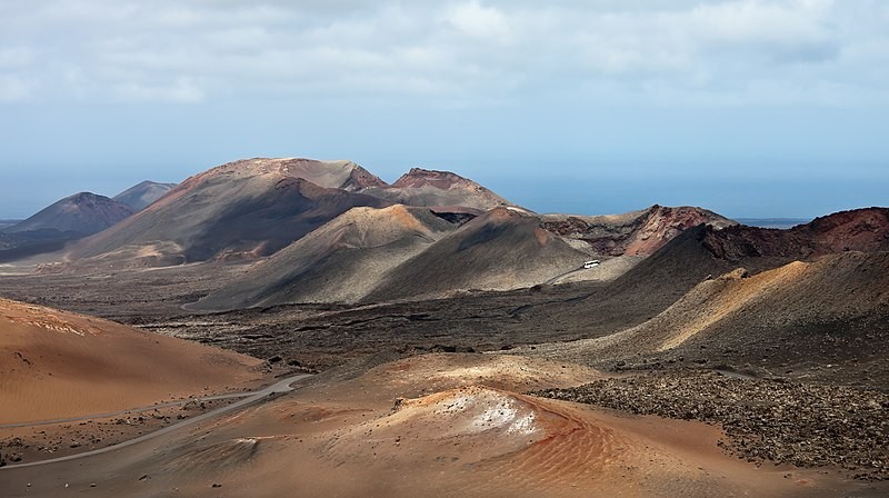
Timanfaya is a national park in the central-western part of Lanzarote known for its unique volcanic landscape and its history of eruptions. The park, declared as such in 1974, covers an area of 51.07 km2 and has more than 25 volcanoes.
The volcanic eruptions that occurred between 1730 and 1736 left an impressive mark, creating a volcanic extension of up to 200 kilometres, known today as the Mountains of Fire.
The park is famous for its geothermal displays, where you can see the heat that still emanates from the earth. Timanfaya is also a place where nature has adapted, with more than 800 species of animals and plants that have found a home in this volcanic environment.
Visiting the park includes the Ruta de los Volcanes (Volcanoes Route), where different types of craters and volcanic materials can be observed. It is an unforgettable experience that allows visitors to understand the magnitude of the eruptions and the importance of conserving this natural treasure.
Moreover, Timanfaya is one of several impressive geological attractions in Lanzarote, including the Cueva de los Verdes and the Jameos del Agua, which offer a unique insight into the island's geology and history.
Average property prices in Tinajo and Yaiza, towns near the Timanfaya National Park, were €1,957/m2 and €3,444/m2, respectively, in June 2024.
Garajonay National Park
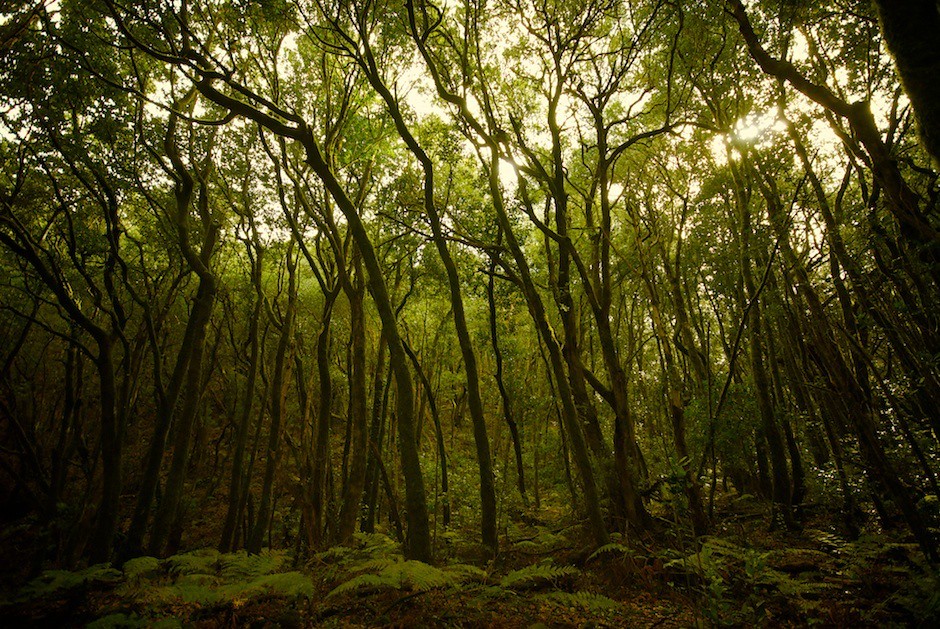
Garajonay National Park, on the island of La Gomera, is one of Spain's most impressive and emblematic natural parks. Declared a national park in 1981 and recognised as a UNESCO World Heritage Site in 1986, it protects a laurel forest, a unique ecosystem dating back to the Cenozoic Era, and traces of the subtropical rainforests that populated the Mediterranean basin millions of years ago.
Garajonay's laurel forest is a magical place, characterised by the humidity and mist that constantly surround it. The so-called "horizontal rain" means that the trees' leaves are always damp, creating an environment reminiscent of Cenozoic forests.
This ecosystem is home to a wide variety of endemic species, including birds such as the blackbird and the chaffinch, as well as bats, which are the only large vertebrates that can survive in this remote environment.
The park extends between 800 and 1,487 metres above sea level, and its relief is characteristic of a volcanic island, with deep ravines and rocks rising through the dense vegetation. The park's network of trails allows visitors to enjoy the beauty of this place safely and comfortably.
The park's history is also fascinating: its name comes from the legend of Gara and Jonay, two lovers who threw themselves from the island's highest peak to spend eternity together because of their impossible love.
The Garajonay National Park covers part of six towns on La Gomera, with the visitor centre and main entrance to the park in Agulo, where house prices in June 2024 were €1,417/m2.
Doñana National Park
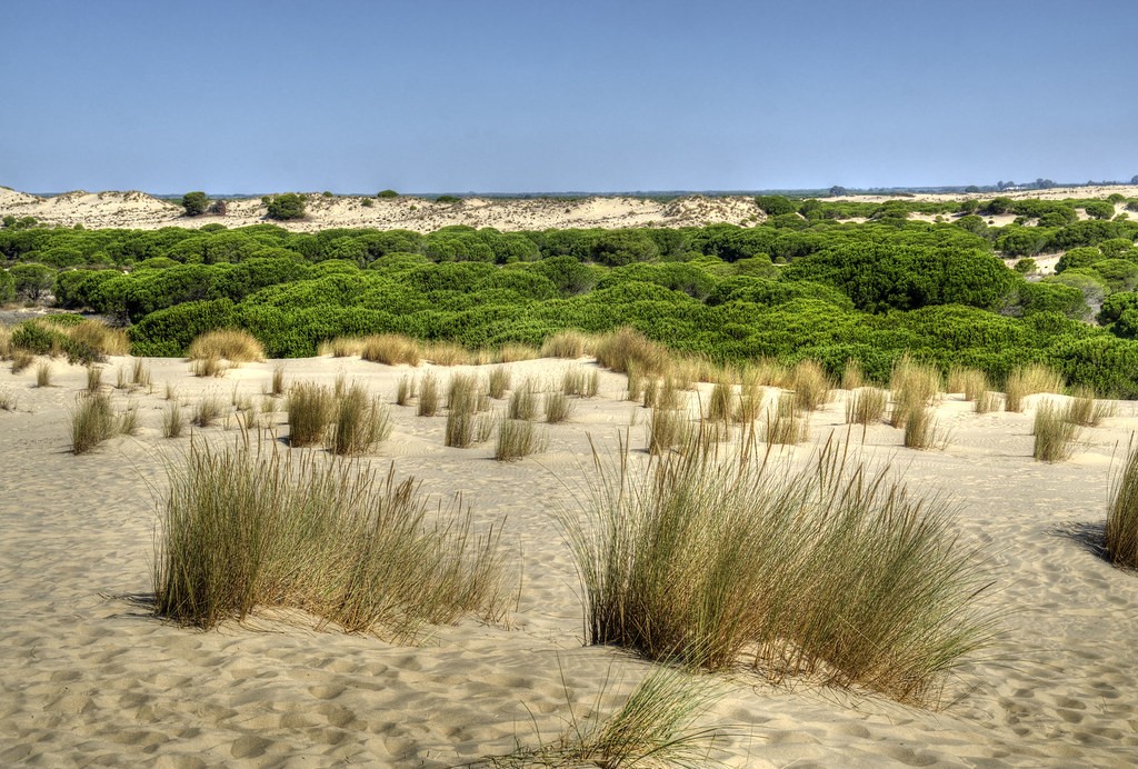
Doñana National Park is one of Spain's most precious and emblematic natural spaces. Located in the southwest of the country, in the provinces of Huelva, Seville and Cadiz, this park was declared a World Heritage Site by UNESCO in 1994 and is considered one of Europe's most important wetlands.
Covering an area of more than 54,000 hectares, Doñana is home to an impressive diversity of ecosystems, from the marshes of the Guadalquivir River estuary to the Atlantic Coast's moving dunes. This mosaic of environments is home to more than 4,000 species of flora and fauna, including some of the planet's most endangered, such as the Iberian lynx and the imperial eagle.
Doñana's history dates back thousands of years when the area was inhabited by prehistoric populations. Over the centuries, the park has witnessed the presence of Phoenicians, Romans, Visigoths and Arabs, who have left their mark on the area. More recently, in the 15th century, it became a royal hunting reserve, which marked the beginning of its protection and conservation.
Today, it receives more than 250,000 visitors a year, attracted by its natural beauty and ecological wealth. However, Doñana also faces significant environmental challenges, such as pollution, overexploitation of water resources and pressure from urban development in the surrounding area.
The largest area occupied by the natural space is in Huelva province, in Almonte, where property prices were €977/m2 in June 2024.
Picos de Europa National Park
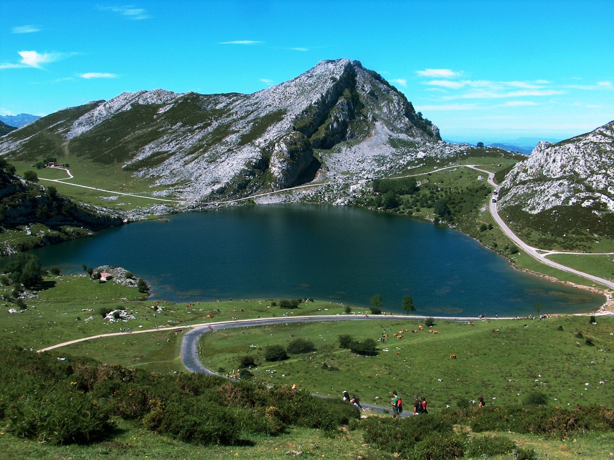
The Picos de Europa are a mountain massif in northern Spain, on the border between the autonomous regions of Asturias, Cantabria and Castile-Leon. This impressive massif was declared a National Park in 1918 and is considered one of the country's most valued natural treasures.
With a surface area of more than 64,000 hectares, it stands out for its imposing alpine landscape, characterised by high peaks, deep glacial valleys, glacial lakes and unique vegetation and fauna.
Among its most emblematic peaks are Torrecerredo (2,648 metres), Naranjo de Bulnes (2,519 metres) and Picu Urriellu (2,519 metres), the latter known as the "Horn" and considered one of the icons of Spanish mountaineering.
Besides their natural beauty, the Picos de Europa are home to a wealth of culture and heritage. Its valleys and villages preserve ancestral traditions, such as migratory livestock farming, cheese-making and artisan crafts. The park also has numerous archaeological and architectural remains, such as prehistoric caves, Romanesque churches and Celtic forts.
One of its main attractions is its outdoor activities, such as hiking, climbing, caving and skiing.
However, like Doñana, this park also faces significant challenges, such as tourist pressure, rural depopulation and the effects of climate change. Therefore, conservation and sustainable management of this national park is essential to preserve its natural and cultural wealth for future generations.
This limestone formation extends across Asturias, Leon and Cantabria, however, it is most prominent in Cabrales, the Asturian town, where house prices were €934/m2 in June 2024.
Ses Illetes, Formentera's most famous beach
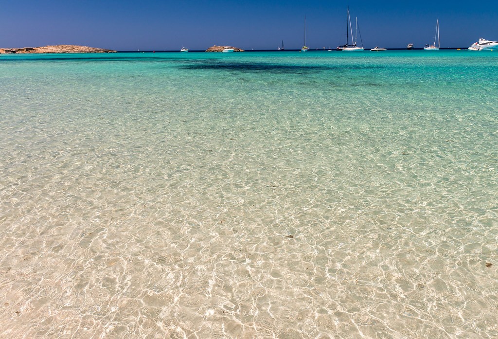
Located at the northern tip of the island of Formentera, Ses Illetes is one of the island's most stunning and renowned beaches. Often named one of the most beautiful beaches in the world, Ses Illetes is located within the Ses Salines de Eivissa and Formentera Natural Park.
Spanning more than 450 metres, it is divided into two parts due to a small rocky area in the centre. Facing the coast are several islets known as Illa de Tramuntana, Illa des Forn, Escull des Pou, Illa Redona and Escull d'en Palla, giving the landscape a unique appearance.
The most outstanding features are its calm, shallow aquamarine waters that contrast with the white sand, creating an idyllic landscape.
The beach's vastness allows visitors to easily settle on the sand, especially in the northern area, where the Trucadors peninsula becomes an arm of sand that connects with Llevant Beach. Continuing northwards, you reach the tip of the island, from where you can see the neighbouring island of Espalmador.
In Formentera, the average price of homes for sale in June 2024 was €8,361/m2.
Flysch on the coast of Gipuzkoa, UNESCO Geopark
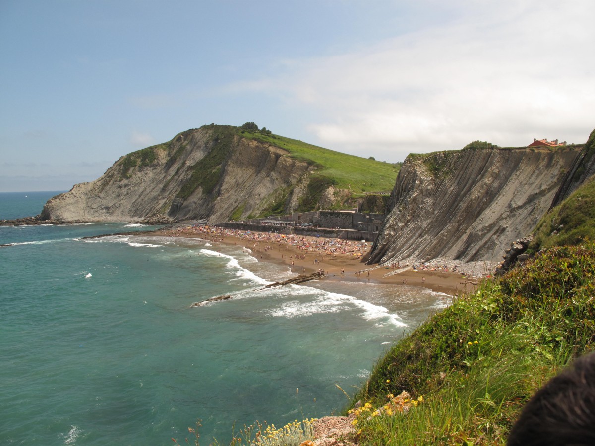
Flysch is a unique rock formation that stretches for 13 kilometres along the coast of Gipuzkoa, between the towns of Deba and Zumaia. This impressive succession of cliffs and rock strata has a geological history of more than 60 million years.
These rock layers, known as "tidal flats", feature alternating hard and soft materials, giving them the appearance of stacked sheets. This phenomenon is due to the collision of the Iberian and European tectonic plates during the formation of the Bay of Biscay, approximately 50 million years ago.
Flysch is a strikingly beautiful and photogenic landscape that has captivated photographers and geologists alike. Declared a UNESCO Geopark in 2015, this protected area offers visitors the opportunity to delve into Earth's history through coastal trails.
One of the most emblematic points is the Punta de Algorri, in Zumaia, from where the imposing vertical layers of Flysch can be seen in all their splendour. Itzurun Beach, wedged between the cliffs, is also an extremely important scientific site, as dinosaur extinction events have been studied there.
The average property price in Guipúzcoa was €3,549/m2 in June 2024.